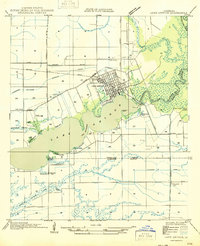
1935 Map of Latania Lake
USGS Topo · Published 1935About this map
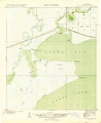
Grand Lake dominates this coastal landscape, showing a network of Louisiana marshland and waterways as they existed in the mid-1930s. The northern portion is defined by the Intracoastal Waterway and the winding course of the Mermentau River, which includes several man-made navigation shortcuts like Willow Cutoff and Long Cutoff. This survey, compiled in part from Air Corps aerial photographs, provides a rare glimpse into the complex hydrology of the region before modern industrial expansion, featuring prominent landforms such as Latania Hill and Onion Hill. Evidence of local transportation and traditional movement through the wetlands is preserved in the form of the Pirogue Trail, which connects Lake Misere to the larger open waters of Grand Lake. Significant points such as Lacassine Point and Hackberry Point delineate the irregular shoreline, while interior elevations like Wild Ridge and Cypress Ridge stand out from the surrounding Maple Marsh.
Find a feature on this map
30 named features on this map. Tap any name to fly to it.
Don’t see what you’re looking for? This feature index may not catch every label — zoom into the map to look around manually.
Map Details
Editions of this 1935 Latania Lake Map
2 editions found

Other maps of this area
1934 · Catfish Lake
USGS Topo · 1:24,000
1934 · Lake Misere
USGS Topo · 1:24,000

1934 · Latania Lake
USGS Topo · 1:24,000

1935 · Lake Misere
USGS Topo · 1:31,680

1935 · Catfish Lake
USGS Topo · 1:31,680
1935 · Grand Chenier
USGS Topo · 1:31,680
1946 · Lake Arthur
USGS Topo · 1:31,680
1946 · Hayes
USGS Topo · 1:31,680
1947 · Thornwell
USGS Topo · 1:31,680
1949 · Hayes
USGS Topo · 1:31,680