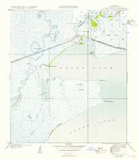
1935 Map of Latania Lake
USGS Topo · Published 1954About this map
Grand Lake and its intricate network of coastal marshlands dominate this mid-1930s coastal survey. The Intracoastal Waterway cuts a straight path through the wetlands, intersecting the winding course of the Mermentau River at an area known simply as Entrance. This landscape is defined by its transition from open water to marsh, featuring named elevations such as Onion Hill and Latania Hill that rise above the surrounding swamp.
Find a feature on this map
30 named features on this map. Tap any name to fly to it.
Don’t see what you’re looking for? This feature index may not catch every label — zoom into the map to look around manually.
Map Details
Editions of this 1935 Latania Lake Map
2 editions found
Other maps of this area

1934 · Catfish Lake
USGS Topo · 1:24,000

1934 · Lake Misere
USGS Topo · 1:24,000

1934 · Latania Lake
USGS Topo · 1:24,000

1935 · Lake Misere
USGS Topo · 1:31,680

1935 · Catfish Lake
USGS Topo · 1:31,680

1935 · Latania Lake
USGS Topo · 1:31,680

1935 · Grand Chenier
USGS Topo · 1:31,680

1946 · Lake Arthur
USGS Topo · 1:31,680

1946 · Hayes
USGS Topo · 1:31,680

1947 · Thornwell
USGS Topo · 1:31,680