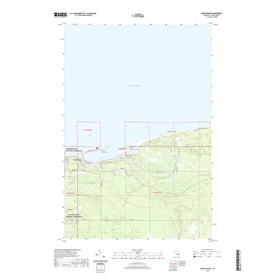
2019 Map of Grand Marais
USGS Topo · Published 2019About this map
Grand Marais sits at the edge of Lake Superior, serving as a protected entry point along this stretch of the Michigan coast. The town is anchored by its sheltered Harbor of Refuge, which is divided into West Bay and East Bay by Lonesome Point and the narrow strip of Lost Island. This 2019 survey documents the interface between the established settlement and the federally protected Pictured Rocks National Lakeshore, where the N Country National Scenic Trail winds through the coastal forests. To the east, the Sucker River and Grand Marais Creek flow toward the Great Lake, creating a complex drainage system that includes Grand Marais Lake. Local history is preserved at sites like Rose Hill Cem and the Holy Rosary Catholic Cem, while the uniquely named Bird Grave landmark stands near the shore of the East Bay.
Find a feature on this map
54 named features on this map. Tap any name to fly to it.
Don’t see what you’re looking for? This feature index may not catch every label — zoom into the map to look around manually.
Map Details
Editions of this 2019 Grand Marais Map
This is the sole edition of this map. No revisions or reprints were ever made.
Other maps of this area

1954 · Sault Sainte Marie
USGS Topo · 1:250,000

1956 · Sault Sainte Marie
USGS Topo · 1:250,000

1957 · Sault Sainte Marie
USGS Topo · 1:250,000

1958 · Sault Sainte Marie
USGS Topo · 1:250,000

1958 · Marquette
USGS Topo · 1:250,000

1960 · Marquette
USGS Topo · 1:250,000

1961 · Marquette
USGS Topo · 1:250,000

1966 · Au Sable Point SE
USGS Topo · 1:24,000
1966 · Grand Sable Lake
USGS Topo · 1:24,000
1968 · Nawakwa Lake
USGS Topo · 1:24,000