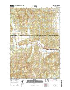
2014 Map of Grand Ronde
USGS Topo · Published 2014About this map
The tribal and civic hub of Grand Ronde Agency serves as the focal point for this 2014 study of the northern Oregon Coast Range foothills. Situated at the convergence of the South Yamhill River and Rogue River, the landscape transitions from the agricultural valley floor at Valley Junction to the prominent heights of Spirit Mtn and Mule Tail Ridge. This area, divided by the Yamhill Co Polk Co line, shows a complex network of forest and ranch roads such as Tindle Creek Rd and SW Agency Creek Rd that navigate the ridges and narrow creek drainages. Local heritage is preserved in sites like the Holmes Cem and Hussey Cem, while modern infrastructure including the Mendenhall Airstrip and the Mountain Springs Ranch Reservoir highlights the continued utility of the land for ranching and transport.
Find a feature on this map
66 named features on this map. Tap any name to fly to it.
Don’t see what you’re looking for? This feature index may not catch every label — zoom into the map to look around manually.
Map Details
Editions of this 2014 Grand Ronde Map
This is the sole edition of this map. No revisions or reprints were ever made.
Other maps of this area

1942 · Sheridan
USGS Topo · 1:62,500

1942 · Spirit Mtn
USGS Topo · 1:62,500

1942 · Valsetz
USGS Topo · 1:62,500

1942 · Dallas
USGS Topo · 1:62,500

1948 · Vancouver
USGS Topo · 1:250,000

1950 · Vancouver
USGS Topo · 1:250,000

1950 · Vancouver
USGS Topo · 1:250,000

1953 · Salem
USGS Topo · 1:250,000

1954 · Salem
USGS Topo · 1:250,000

1955 · Grand Ronde
USGS Topo · 1:62,500