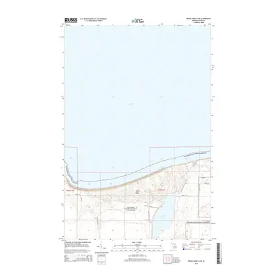
2014 Map of Grand Sable Lake
USGS Topo · Published 2014About this map
Pictured Rocks National Lakeshore dominates this coastal landscape, protecting a massive expanse of the Grand Sable Dunes perched high above the southern shore of Lake Superior. The map details a dramatic transition from the open waters of the Great Lake to the towering sand formations and the inland waters of Grand Sable Lake. The N Country National Scenic Trail winds through the interior, connecting the shoreline to natural landmarks such as Sable Falls and Sable Cr. To the south and east, a network of forest roads including Timber Rd, Lowder Rd, and William Hill Rd provides access to the dense woodlands bordering the dunes. This 2014 survey documents the modern topography of a region where hydrology and geology meet, visible in the drainage patterns of Toves Cr and the strictly defined boundaries of the national lakeshore.
Find a feature on this map
19 named features on this map. Tap any name to fly to it.
Don’t see what you’re looking for? This feature index may not catch every label — zoom into the map to look around manually.
Map Details
Editions of this 2014 Grand Sable Lake Map
This is the sole edition of this map. No revisions or reprints were ever made.
Other maps of this area

1954 · Sault Sainte Marie
USGS Topo · 1:250,000

1956 · Sault Sainte Marie
USGS Topo · 1:250,000

1957 · Sault Sainte Marie
USGS Topo · 1:250,000

1958 · Sault Sainte Marie
USGS Topo · 1:250,000

1958 · Marquette
USGS Topo · 1:250,000

1960 · Marquette
USGS Topo · 1:250,000

1961 · Marquette
USGS Topo · 1:250,000

1966 · Au Sable Point SE
USGS Topo · 1:24,000
1966 · Grand Sable Lake
USGS Topo · 1:24,000
1966 · Au Sable Point
USGS Topo · 1:24,000