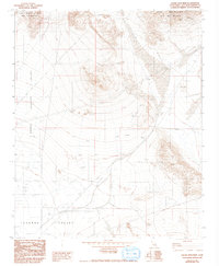
1982 Map of Grand View Mine
USGS Topo · Published 1993About this map
Ord Mountains dominate the horizon of this Mojave Desert landscape, anchoring a region defined by its rugged topography and industrial extraction. The terrain transitions from the high peaks of West Ord Mountain and East Ord Mountain down into the northern reaches of the Lucerne Valley. This 1982 provisional survey documents a network of mineral prospects and established mining operations that characterize the local economy and land use during the late twentieth century. Notable sites including the Grand View Mine, Riley Mine, and Ford Mine are situated throughout the foothills, connected by a sparse network of unimproved roads and trails. Modern infrastructure is represented by an Underground Gas Pipeline cutting through the desert floor, illustrating the intersection of natural resource geography and utility corridors.
Find a feature on this map
10 named features on this map. Tap any name to fly to it.
Don’t see what you’re looking for? This feature index may not catch every label — zoom into the map to look around manually.
Map Details
Editions of this 1982 Grand View Mine Map
3 editions found
Other maps of this area

1901 · Southern California Sheet No. 1
USGS Topo · 1:250,000

1902 · San Gorgonio
USGS Topo · 1:125,000

1904 · Southern California Sheet No. 1
USGS Topo · 1:250,000

1947 · Lucerne Valley
USGS Topo · 1:62,500

1949 · Lucerne Valley
USGS Topo · 1:62,500

1953 · San Bernardino
USGS Topo · 1:250,000

1955 · Old Woman Springs
USGS Topo · 1:62,500

1955 · Ord Mountains
USGS Topo · 1:62,500

1955 · Rodman Mountains
USGS Topo · 1:62,500

1956 · San Bernardino
USGS Topo · 1:250,000