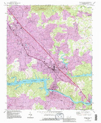
1993 Map of Granite Falls
USGS Topo · Published 1996About this map
Gunpowder Creek and its many tributaries, such as Little Gunpowder Creek and Silver Creek, dominate the Piedmont topography above the Catawba River. This late-century update captures the industrial and community expansion between Hudson and Granite Falls, where numerous country churches like Poovey Chapel and Center Grove Ch served growing local populations. The southern portion of the map is defined by the impounded waters of Rhodhiss Lake and Lake Hickory, created by the Rhodhiss Dam. These reservoirs transformed the river valley from a narrow stream into a series of broad basins. Cultural landmarks are scattered throughout, ranging from the Caldwell Community College campus to the Hudson Drag Strip near the northern edge of the survey area. In the hills, landmarks like Chestnut Mtn and Pilot Mtn provide vertical relief above the spreading residential developments of Saw Mills.
Find a feature on this map
50 named features on this map. Tap any name to fly to it.
Don’t see what you’re looking for? This feature index may not catch every label — zoom into the map to look around manually.
Map Details
Editions of this 1993 Granite Falls Map
This is the sole edition of this map. No revisions or reprints were ever made.
Other maps of this area

1895 · Hickory
USGS Topo · 1:125,000

1905 · Morganton
USGS Topo · 1:125,000

1953 · Charlotte
USGS Topo · 1:250,000

1954 · Charlotte
USGS Topo · 1:250,000

1956 · Valdese
USGS Topo · 1:24,000

1956 · Lenoir
USGS Topo · 1:24,000

1956 · Drexel
USGS Topo · 1:24,000

1956 · Lenoir
USGS Topo · 1:62,500

1960 · Charlotte
USGS Topo · 1:250,000

1962 · Charlotte
USGS Topo · 1:250,000