
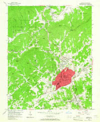
1956 Map of Lenoir
USGS Topo · Published 1958About this map
Lenoir serves as the focal point of this mid-century survey, its urban core detailed with municipal landmarks like the Courthouse, City Hall, and Caldwell Memorial Hospital. The town's industrial and transport identity is defined by the Southern railroad line, which skirts the southern edge through Whitnel, while the Lenoir Golf Club and the Armory mark the outskirts of its 1950s footprint. Beyond the city center, the terrain transitions into the dense woods of the Pisgah National Forest, where a network of rural life is preserved through numerous community hubs such as Shiloh Ch, Hartley Hill Ch, and the Bushtown Sch. To the north, the Yadkin River flows through the scenic Happy Valley, connecting the settlement of Patterson to the broader Yadkin Valley. This topography illustrates the juxtaposition of a growing Appalachian manufacturing center against the traditional agrarian landscape of the North Carolina foothills.
Find a feature on this map
76 named features on this map. Tap any name to fly to it.
Don’t see what you’re looking for? This feature index may not catch every label — zoom into the map to look around manually.
Map Details
Editions of this 1956 Lenoir Map
2 editions found
Other maps of this area

1889 · Wilkesboro
USGS Topo · 1:125,000

1891 · Wilkesboro
USGS Topo · 1:125,000

1893 · Cranberry
USGS Topo · 1:125,000

1895 · Hickory
USGS Topo · 1:125,000

1895 · Cranberry
USGS Topo · 1:125,000

1899 · Cranberry
USGS Topo · 1:125,000

1902 · Cranberry
USGS Topo · 1:125,000

1905 · Morganton
USGS Topo · 1:125,000

1936 · Blowing Rock
USGS Topo · 1:48,000

1942 · Blowing Rock
USGS Topo · 1:62,500