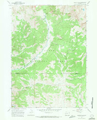
1967 Map of Granite Falls
USGS Topo · Published 1971About this map
Hot Spring and the Granite Creek Campground define the recreational and natural landscape of this high-altitude Wyoming region during the late 1960s. Located within the Teton National Forest, the map captures a transition between the wild peaks of the Wyoming Range and early industrial exploration. Evidence of resource extraction is visible through the presence of several Oil Wells and a Mine situated near the banks of Granite Creek.
Find a feature on this map
23 named features on this map. Tap any name to fly to it.
Don’t see what you’re looking for? This feature index may not catch every label — zoom into the map to look around manually.
Map Details
Editions of this 1967 Granite Falls Map
This is the sole edition of this map. No revisions or reprints were ever made.
Other maps of this area

1907 · Gros Ventre
USGS Topo · 1:125,000

1910 · Gros Ventre
USGS Topo · 1:125,000

1931 · Jackson
USGS Topo · 1:125,000

1935 · Jackson
USGS Topo · 1:125,000

1955 · Driggs
USGS Topo · 1:250,000

1958 · Driggs
USGS Topo · 1:250,000

1962 · Driggs
USGS Topo · 1:250,000
1965 · Turquoise Lake
USGS Topo · 1:24,000
1965 · Bull Creek
USGS Topo · 1:24,000
1965 · Clause Peak
USGS Topo · 1:24,000