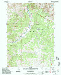
1996 Map of Granite Falls
USGS Topo · Published 1998About this map
Granite Hot Springs serves as a focal point in this mountainous landscape of western Wyoming, where the thermal waters meet the cold flow of Granite Creek. The terrain is defined by its administrative and wildland status, spanning the Teton National Forest and the Gros Ventre Wilderness. Notable features such as The Open Door and Game Hill punctuate the landscape, while the presence of a Footbridge and scattered Corrals indicate a history of backcountry travel and stock management. An interesting industrial outlier, an Oil Well, appears south of Granite Creek, contrasting with the surrounding Shoal Creek Wilderness Study Area. The map also meticulously traces the Teton Co Sublette Co line, providing a clear record of jurisdictional boundaries through the drainage of Shoal Creek and Mac Leod Lake.
Find a feature on this map
29 named features on this map. Tap any name to fly to it.
Don’t see what you’re looking for? This feature index may not catch every label — zoom into the map to look around manually.
Map Details
Editions of this 1996 Granite Falls Map
This is the sole edition of this map. No revisions or reprints were ever made.
Other maps of this area

1907 · Gros Ventre
USGS Topo · 1:125,000

1910 · Gros Ventre
USGS Topo · 1:125,000

1931 · Jackson
USGS Topo · 1:125,000

1935 · Jackson
USGS Topo · 1:125,000

1955 · Driggs
USGS Topo · 1:250,000

1958 · Driggs
USGS Topo · 1:250,000

1962 · Driggs
USGS Topo · 1:250,000
1965 · Turquoise Lake
USGS Topo · 1:24,000
1965 · Bull Creek
USGS Topo · 1:24,000
1965 · Clause Peak
USGS Topo · 1:24,000