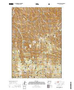
2020 Map of Granite Meadows
USGS Topo · Published 2020About this map
Umatilla National Forest covers much of this Umatilla County landscape, which is defined by a dense network of gulches and canyons. To the north, the Warner Family Cem is situated near Blue Gulch, providing a specific point of interest for family historians tracing pioneer lineages. The terrain transitions from high plateaus like Table Mtn and South Prairie to deep drainage features such as Ridenor Canyon and California Gulch.
Find a feature on this map
46 named features on this map. Tap any name to fly to it.
Don’t see what you’re looking for? This feature index may not catch every label — zoom into the map to look around manually.
Map Details
Editions of this 2020 Granite Meadows Map
This is the sole edition of this map. No revisions or reprints were ever made.
Other maps of this area

1953 · Pendleton
USGS Topo · 1:250,000

1956 · Pendleton
USGS Topo · 1:250,000

1967 · Nye
USGS Topo · 1:24,000

1967 · Lehman Springs
USGS Topo · 1:24,000

1967 · Granite Meadows
USGS Topo · 1:24,000

1967 · Carney Butte
USGS Topo · 1:24,000

1967 · Pilot Rock
USGS Topo · 1:24,000

1967 · Ukiah
USGS Topo · 1:24,000

1967 · Owens Butte
USGS Topo · 1:24,000
1967 · Sevenmile Creek
USGS Topo · 1:24,000