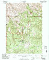
1995 Map of Granite Meadows
USGS Topo · Published 1998About this map
The Umatilla National Forest landscape within the Blue Mountains is defined by a deep network of drainages and upland flats as mapped in the mid-1990s. The topography is characterized by dramatic elevation shifts between features like Table Mountain and the surrounding canyons, such as Beeman Canyon and Cold Spring Canyon. One of the most significant historical markers on this sheet is Pine Grove (Site), located along Kenny Creek, which serves as a remnant of earlier habitation in this high-elevation terrain.
Find a feature on this map
38 named features on this map. Tap any name to fly to it.
Don’t see what you’re looking for? This feature index may not catch every label — zoom into the map to look around manually.
Map Details
Editions of this 1995 Granite Meadows Map
This is the sole edition of this map. No revisions or reprints were ever made.
Other maps of this area

1953 · Pendleton
USGS Topo · 1:250,000

1956 · Pendleton
USGS Topo · 1:250,000

1967 · Nye
USGS Topo · 1:24,000

1967 · Lehman Springs
USGS Topo · 1:24,000

1967 · Granite Meadows
USGS Topo · 1:24,000

1967 · Carney Butte
USGS Topo · 1:24,000

1967 · Pilot Rock
USGS Topo · 1:24,000

1967 · Ukiah
USGS Topo · 1:24,000

1967 · Owens Butte
USGS Topo · 1:24,000
1967 · Sevenmile Creek
USGS Topo · 1:24,000