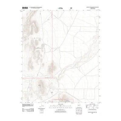
2011 Map of Granite Mountain
USGS Topo · Published 2011About this map
Granite Mountain dominates this portion of the high desert landscape within the Cibola National Forest, where the terrain transitions from steep rocky peaks to the drainage basins of the Rio Grande valley. The settlement of Heister is situated in the southwest, connected by a network of specialized routes including Road 534 and Forest 506 Rd. This area reflects the modern management of federal lands, balancing ranching infrastructure like Jornada Tank with the natural topography of Anchor Canyon. The seasonal flow of La Jencia Creek carves through the eastern flats, illustrating the critical role of water management and natural hydrology in this arid Socorro County environment. The map captures a high-elevation backcountry maintained for forestry and grazing, characterized by its isolation and specialized access roads.
Find a feature on this map
11 named features on this map. Tap any name to fly to it.
Don’t see what you’re looking for? This feature index may not catch every label — zoom into the map to look around manually.
Map Details
Editions of this 2011 Granite Mountain Map
This is the sole edition of this map. No revisions or reprints were ever made.
Other maps of this area

1954 · Socorro
USGS Topo · 1:250,000

1958 · Socorro
USGS Topo · 1:250,000

1959 · Magdalena
USGS Topo · 1:62,500

1959 · Riley
USGS Topo · 1:62,500

1962 · Socorro
USGS Topo · 1:250,000

1963 · Arroyo Landavaso
USGS Topo · 1:24,000

1964 · Silver Hill
USGS Topo · 1:24,000
1964 · Mesa Cencerro
USGS Topo · 1:24,000
1979 · Magdalena
USGS Topo · 1:100,000
1985 · Granite Mountain
USGS Topo · 1:24,000