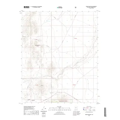
2020 Map of Granite Mountain
USGS Topo · Published 2020About this map
Magdalena serves as the primary hub in this arid landscape of Socorro County, situated on the northern edge of the Cibola National Forest. The village is anchored by historical local landmarks such as the Magdalena Community Cem, which provides a vital point of reference for genealogists and local historians. The surrounding terrain is defined by dramatic elevation changes, ranging from the prominent summit of Granite Mtn to the winding drainage of La Jencia Creek and the deep cut of Anchor Canyon.
Find a feature on this map
23 named features on this map. Tap any name to fly to it.
Don’t see what you’re looking for? This feature index may not catch every label — zoom into the map to look around manually.
Map Details
Editions of this 2020 Granite Mountain Map
This is the sole edition of this map. No revisions or reprints were ever made.
Other maps of this area

1954 · Socorro
USGS Topo · 1:250,000

1958 · Socorro
USGS Topo · 1:250,000

1959 · Magdalena
USGS Topo · 1:62,500

1959 · Riley
USGS Topo · 1:62,500

1962 · Socorro
USGS Topo · 1:250,000

1963 · Arroyo Landavaso
USGS Topo · 1:24,000

1964 · Silver Hill
USGS Topo · 1:24,000
1964 · Mesa Cencerro
USGS Topo · 1:24,000
1979 · Magdalena
USGS Topo · 1:100,000
1985 · Granite Mountain
USGS Topo · 1:24,000