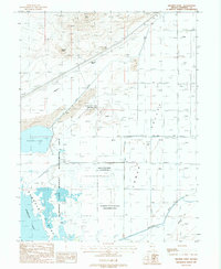
1987 Map of Granite Point
USGS Topo · Published 1988About this map
The Emigrant Trail traces a historical path across the desert landscape of Pershing County in this late-1980s survey. The terrain is dominated by the vast Humboldt State Wildlife Management Area, which encompasses the wetlands and fluctuating shorelines of Toulon Lake and the northern reaches of Humboldt Lake. This environment highlights the critical role of the Humboldt River drainage in an otherwise arid basin. Infrastructure for transportation and commerce is concentrated near the base of Granite Point, where Gravel Pits and various Prospects suggest local mineral extraction. To the east, Derby Field and an Airway Beacon signify the area's importance for regional aviation, while scattered Storage Bins and a Gaging Sta reflect the management of resources in the Lower Valley.
Find a feature on this map
14 named features on this map. Tap any name to fly to it.
Don’t see what you’re looking for? This feature index may not catch every label — zoom into the map to look around manually.
Map Details
Editions of this 1987 Granite Point Map
This is the sole edition of this map. No revisions or reprints were ever made.
Other maps of this area

1908 · Carson Sink
USGS Topo · 1:250,000

1910 · Carson Sink
USGS Topo · 1:250,000

1931 · Lovelock
USGS Topo · 1:250,000

1935 · Lovelock
USGS Topo · 1:250,000

1951 · Carson Sink
USGS Topo · 1:62,500

1955 · Lovelock
USGS Topo · 1:250,000

1956 · Toulon
USGS Topo · 1:62,500

1956 · Lovelock
USGS Topo · 1:62,500

1957 · Reno
USGS Topo · 1:250,000

1959 · Lovelock
USGS Topo · 1:250,000