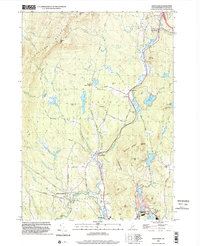
1998 Map of Grantham
USGS Topo · Published 2002About this map
Croydon Mountain and the steep slopes of the Plainfield and Cornish borderlands dominate the western half of this late-1990s landscape in Sullivan County. The North Branch Sugar River winds southward through the central valley, connecting a string of small New Hampshire settlements including Croydon, Croydon Four Corners, and Croydon Flat. This drainage basin is a complex network of brooks and ponds, from the secluded Red Leaf Pond to the larger Lake Coniston in the east.
Find a feature on this map
75 named features on this map. Tap any name to fly to it.
Don’t see what you’re looking for? This feature index may not catch every label — zoom into the map to look around manually.
Map Details
Editions of this 1998 Grantham Map
This is the sole edition of this map. No revisions or reprints were ever made.
Other maps of this area

1902 · Sunapee
USGS Topo · 1:62,500

1905 · Sunapee
USGS Topo · 1:62,500

1906 · Hanover
USGS Topo · 1:62,500

1907 · Sunapee
USGS Topo · 1:62,500

1908 · Hanover
USGS Topo · 1:62,500

1926 · Claremont
USGS Topo · 1:62,500

1927 · Mascoma
USGS Topo · 1:62,500

1929 · Claremont
USGS Topo · 1:62,500

1932 · Mascoma
USGS Topo · 1:62,500

1950 · Glens Falls
USGS Topo · 1:250,000