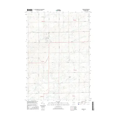
2015 Map of Granton
USGS Topo · Published 2015About this map
Granton and Lynn serve as the primary hubs for this agricultural region of Clark County, where a dense grid of section-line roads like Hill Rd and Maple Rd defines the landscape. The geography is heavily influenced by the drainage patterns of Cunningham Cr and its tributaries, which meander across the township lines. For those researching local lineages, the map identifies several rural burying grounds, including Windfall Cem near the town center and Zion Cem further east. A notable modern infrastructure feature is Cunningham Airport, situated south of the Lynn settlement. The land remains divided into its original public land survey system blocks, visible here as townships t24n r1w and t24n r1e, reflecting a traditional Midwestern settlement pattern where small villages developed along the creeks and township corners.
Find a feature on this map
33 named features on this map. Tap any name to fly to it.
Don’t see what you’re looking for? This feature index may not catch every label — zoom into the map to look around manually.
Map Details
Editions of this 2015 Granton Map
This is the sole edition of this map. No revisions or reprints were ever made.
Other maps of this area

1953 · Neillsville
USGS Topo · 1:62,500

1953 · Eau Claire
USGS Topo · 1:250,000

1954 · Granton
USGS Topo · 1:62,500

1957 · City Point
USGS Topo · 1:48,000

1958 · Eau Claire
USGS Topo · 1:250,000

1958 · Hatfield
USGS Topo · 1:48,000

1964 · Eau Claire
USGS Topo · 1:250,000

1970 · City Point NE
USGS Topo · 1:24,000
1970 · City Point NW
USGS Topo · 1:24,000
1970 · Hatfield NE
USGS Topo · 1:24,000