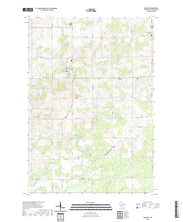
2022 Map of Granton
USGS Topo · Published 2022About this map
The village of Granton serves as the central hub for this rural Clark County landscape, where agriculture and community landmarks have persisted through the decades. Located near the intersection of Paulson Ave and Co Rd K, the village is surrounded by a network of family and community burial grounds, including Windfall Cem, Zion Cem, and Yolo Cem. The landscape is defined by the winding paths of Cunningham Cr and Middle Br O'Neil Cr, which drain the patchwork of woodlots and fields that characterize this portion of Wisconsin.
Find a feature on this map
37 named features on this map. Tap any name to fly to it.
Don’t see what you’re looking for? This feature index may not catch every label — zoom into the map to look around manually.
Map Details
Editions of this 2022 Granton Map
This is the sole edition of this map. No revisions or reprints were ever made.
Other maps of this area

1953 · Neillsville
USGS Topo · 1:62,500

1953 · Eau Claire
USGS Topo · 1:250,000

1954 · Granton
USGS Topo · 1:62,500

1957 · City Point
USGS Topo · 1:48,000

1958 · Eau Claire
USGS Topo · 1:250,000

1958 · Hatfield
USGS Topo · 1:48,000

1964 · Eau Claire
USGS Topo · 1:250,000

1970 · City Point NE
USGS Topo · 1:24,000
1970 · City Point NW
USGS Topo · 1:24,000
1970 · Hatfield NE
USGS Topo · 1:24,000