
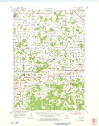
1954 Map of Granton
USGS Topo · Published 1956About this map
The Granton area in central Wisconsin exhibits a landscape defined by a dense network of rural one-room schoolhouses and country churches during the mid-1950s. This survey captures a period when the agricultural grid was still punctuated by numerous local institutions, from Merryvale Sch in the west to Nasonville Ch in the east. The terrain transitions from the headwaters of O'Neill Creek and Bear Creek toward more distinctive landforms like Burdock Mound and the Lindsey Bluffs, which rise above the surrounding farmland.
Find a feature on this map
68 named features on this map. Tap any name to fly to it.
Don’t see what you’re looking for? This feature index may not catch every label — zoom into the map to look around manually.
Map Details
Editions of this 1954 Granton Map
2 editions found
Other maps of this area

1902 · Marathon
USGS Topo · 1:125,000

1953 · Neillsville
USGS Topo · 1:62,500

1953 · Abbotsford
USGS Topo · 1:48,000

1953 · Owen
USGS Topo · 1:48,000

1953 · Stratford
USGS Topo · 1:48,000

1953 · Eau Claire
USGS Topo · 1:250,000

1954 · Marshfield
USGS Topo · 1:62,500

1957 · Pittsville
USGS Topo · 1:48,000

1957 · City Point
USGS Topo · 1:48,000

1958 · Eau Claire
USGS Topo · 1:250,000