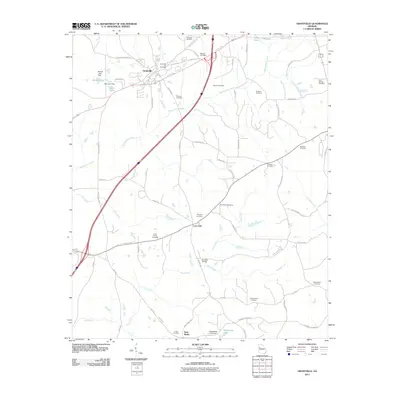
2011 Map of Grantville
USGS Topo · Published 2011About this map
Grantville serves as the primary hub in this Georgia landscape, situated north of the smaller settlements of Lone Oak and Saint Marks. The map reveals a high concentration of burial grounds, which offer significant value for genealogical research, including the Grantville City Cemetery, Holly Springs Cemetery, and the uniquely named Possum Trot Cemetery. The terrain is defined by a network of waterways such as Yellowjacket Creek, Blue Creek, and Flat Creek, which are crossed by infrastructure like the Burdette Bridge. Small-scale reservoirs including Brewer Lake and Whitehead Lake are scattered across the quadrangle, reflecting the local agricultural and water management practices of the early twenty-first century. This era shows a well-established road network, from named local routes like Charlie Patterson Rd to the larger highway corridors that connect these rural communities.
Find a feature on this map
71 named features on this map. Tap any name to fly to it.
Don’t see what you’re looking for? This feature index may not catch every label — zoom into the map to look around manually.
Map Details
Editions of this 2011 Grantville Map
This is the sole edition of this map. No revisions or reprints were ever made.
Other maps of this area

1953 · Atlanta
USGS Topo · 1:250,000

1957 · Atlanta
USGS Topo · 1:250,000

1958 · Atlanta
USGS Topo · 1:250,000

1964 · Hogansville
USGS Topo · 1:24,000
1964 · Mountville
USGS Topo · 1:24,000

1964 · Grantville
USGS Topo · 1:24,000
1964 · Odessadale
USGS Topo · 1:24,000

1965 · Newnan South
USGS Topo · 1:24,000
1965 · Newnan SW
USGS Topo · 1:24,000

1965 · Sharpsburg
USGS Topo · 1:24,000