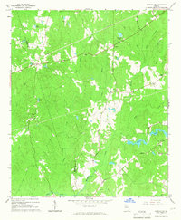
1965 Map of Newnan SW
USGS Topo · Published 1966About this map
Stallings Crossroads and Dresden serve as quiet focal points in this mid-1960s landscape, where small community hubs are defined by a dense network of country churches and family-named landmarks. The terrain is marked by a transition from the agricultural clearings near Corinth in the south to the more wooded drainages of Caney Creek and Sandy Creek. Religious and social life is anchored by numerous local congregations, including Emory Chapel, St Smyrna Ch, and Dents Chapel.
Find a feature on this map
31 named features on this map. Tap any name to fly to it.
Don’t see what you’re looking for? This feature index may not catch every label — zoom into the map to look around manually.
Map Details
Editions of this 1965 Newnan SW Map
2 editions found
Other maps of this area

1899 · Wedowee
USGS Topo · 1:125,000

1902 · Wedowee
USGS Topo · 1:125,000

1953 · Atlanta
USGS Topo · 1:250,000

1957 · Atlanta
USGS Topo · 1:250,000

1958 · Atlanta
USGS Topo · 1:250,000

1964 · Hogansville
USGS Topo · 1:24,000

1964 · Hillcrest
USGS Topo · 1:24,000

1964 · Grantville
USGS Topo · 1:24,000
1964 · Franklin
USGS Topo · 1:24,000
1964 · Lowell
USGS Topo · 1:24,000