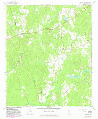
1965 Map of Newnan SW
USGS Topo · Published 1983About this map
Stallings Crossroad and the rural community of Dresden anchor this 1965 survey of the southwestern reaches of Coweta County. The landscape is defined by its social and spiritual centers, with several congregations such as St Smyrnas Ch, Dents Chapel, and Wesley Chapel scattered throughout the woodland and farm clearings. This network of small chapels and churches provides a clear look at the mid-century settlement pattern in Georgia's Piedmont region before major suburban expansion transformed the area.
Find a feature on this map
33 named features on this map. Tap any name to fly to it.
Don’t see what you’re looking for? This feature index may not catch every label — zoom into the map to look around manually.
Map Details
Editions of this 1965 Newnan SW Map
2 editions found
Other maps of this area

1899 · Wedowee
USGS Topo · 1:125,000

1902 · Wedowee
USGS Topo · 1:125,000

1953 · Atlanta
USGS Topo · 1:250,000

1957 · Atlanta
USGS Topo · 1:250,000

1958 · Atlanta
USGS Topo · 1:250,000

1964 · Hogansville
USGS Topo · 1:24,000

1964 · Hillcrest
USGS Topo · 1:24,000

1964 · Grantville
USGS Topo · 1:24,000
1964 · Franklin
USGS Topo · 1:24,000
1964 · Lowell
USGS Topo · 1:24,000