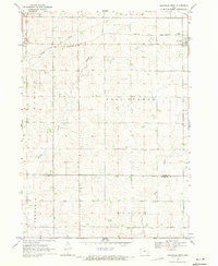
1969 Map of Granville West
USGS Topo · Published 1971About this map
Granville stands as the primary hub in this late 1960s agricultural survey of Northwest Iowa. The town is situated in the northeast corner of the sheet, where the Chicago and North Western railroad line facilitates the movement of grain and goods across the prairie. The landscape is defined by the headwaters and meandering courses of several drainage systems, including the Floyd River in the west and Willow Creek cutting through the central township sections. This map captures the region's rigid section-line road network, illustrating how the townships of Holland, Nassau, and East Orange were partitioned for large-scale farming. Notable industrial landmarks such as a local Gravel Pit and the sewage disposal facility near the rail line reflect the essential infrastructure supporting this rural community just before the turn of the decade.
Find a feature on this map
14 named features on this map. Tap any name to fly to it.
Don’t see what you’re looking for? This feature index may not catch every label — zoom into the map to look around manually.
Map Details
Editions of this 1969 Granville West Map
This is the sole edition of this map. No revisions or reprints were ever made.
Other maps of this area

1954 · Fairmont
USGS Topo · 1:250,000

1954 · Fort Dodge
USGS Topo · 1:250,000

1955 · Sioux City
USGS Topo · 1:250,000

1955 · Sioux Falls
USGS Topo · 1:250,000

1957 · Fort Dodge
USGS Topo · 1:250,000

1958 · Sioux City
USGS Topo · 1:250,000

1958 · Sioux Falls
USGS Topo · 1:250,000

1958 · Fort Dodge
USGS Topo · 1:250,000

1958 · Fairmont
USGS Topo · 1:250,000

1959 · Sioux City
USGS Topo · 1:250,000