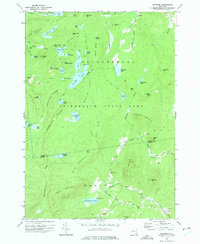
1973 Map of Graphite
USGS Topo · Published 1975About this map
Hague and the inland settlement of Graphite anchor the southern reaches of this landscape, situated near the Essex County and Warren County line. The terrain is characterized by a dense concentration of glacial water bodies within the Adirondack State Park, including the expansive Putnam Pond and the secluded Pharaoh Lake. The presence of Graphite suggests the region's industrial ties to mineral extraction, while the surrounding peaks like Thunderbolt Mountain and Grizzle Ocean Mountain define the high-relief interior. Genealogists may find value in the May Memorial Cem near Hague and the lonely Cem located north of Chilson. These small hamlets and cemeteries are linked by a sparse network of roads such as Armstrong Road and Summit Drive, which navigate around prominent landmarks like Old Fort Mtn and Fernette Mtn.
Find a feature on this map
60 named features on this map. Tap any name to fly to it.
Don’t see what you’re looking for? This feature index may not catch every label — zoom into the map to look around manually.
Map Details
Editions of this 1973 Graphite Map
2 editions found
Other maps of this area

1893 · Whitehall
USGS Topo · 1:62,500

1894 · Ticonderoga
USGS Topo · 1:62,500

1895 · Whitehall
USGS Topo · 1:62,500

1895 · Paradox Lake
USGS Topo · 1:62,500

1896 · Ticonderoga
USGS Topo · 1:62,500

1897 · Bolton
USGS Topo · 1:62,500

1897 · Paradox Lake
USGS Topo · 1:62,500

1898 · Whitehall
USGS Topo · 1:62,500

1900 · Bolton
USGS Topo · 1:62,500

1902 · Whitehall
USGS Topo · 1:62,500