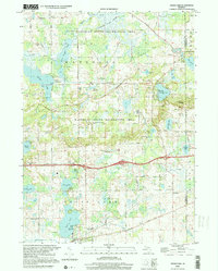
1998 Map of Grass Lake
USGS Topo · Published 2001About this map
The Waterloo State Recreation Area dominates the northern half of this landscape, preserving a complex wetland and lake system at the intersection of Jackson and Washtenaw counties. Small settlements like Trist and Waterloo are captured alongside family-named rural infrastructure, such as the Trist Millpond and Mt Hope Sch. The terrain is characterized by numerous kettle lakes and marshes, including Little Portage Lake, Clear Lake, and the expansive Grass Lake in the south. The presence of the Railroad Grade and a Weigh Station near the central transit corridor illustrates the region's movement of goods between larger Michigan hubs. Local history is deeply etched into the land here through sites like St Jacob Ch and the Michigan Baptist Assembly Camp, showing a rural community shaped by both religious assembly and recreational use of the surrounding lakes and hills like Sackrider Hill.
Find a feature on this map
75 named features on this map. Tap any name to fly to it.
Don’t see what you’re looking for? This feature index may not catch every label — zoom into the map to look around manually.
Map Details
Editions of this 1998 Grass Lake Map
This is the sole edition of this map. No revisions or reprints were ever made.
Other maps of this area

1919 · Stockbridge
USGS Topo · 1:62,500

1919 · Rives Junction
USGS Topo · 1:62,500

1921 · Rives Junction
USGS Topo · 1:62,500

1922 · Stockbridge
USGS Topo · 1:62,500

1935 · Jackson
USGS Topo · 1:48,000

1939 · Jackson
USGS Topo · 1:62,500

1942 · Stockbridge
USGS Topo · 1:62,500

1948 · Manchester
USGS Topo · 1:62,500

1949 · Manchester
USGS Topo · 1:62,500

1958 · Grand Rapids
USGS Topo · 1:250,000