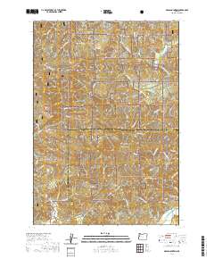
2020 Map of Grass Mountain
USGS Topo · Published 2020About this map
The Siuslaw National Forest dominates this section of the Oregon Coast Range, where steep timberlands are carved by a dense network of drainages. High points like Grass Mtn and Easter Ridge provide the primary vertical relief, while the Alsea Valley in the southeast corner offers a small pocket of lower, flatter terrain near the confluence of the Alsea River. The map reveals a landscape shaped by both natural topography and administrative history, clearly marking the Lincoln Co Benton Co line as it cuts through the mountains.
Find a feature on this map
53 named features on this map. Tap any name to fly to it.
Don’t see what you’re looking for? This feature index may not catch every label — zoom into the map to look around manually.
Map Details
Editions of this 2020 Grass Mountain Map
This is the sole edition of this map. No revisions or reprints were ever made.
Other maps of this area

1939 · Marys Peak
USGS Topo · 1:62,500

1942 · Marys Peak
USGS Topo · 1:62,500

1942 · Alsea
USGS Topo · 1:62,500

1942 · Tidewater
USGS Topo · 1:62,500

1942 · Toledo
USGS Topo · 1:62,500

1953 · Salem
USGS Topo · 1:250,000

1954 · Salem
USGS Topo · 1:250,000

1956 · Alsea
USGS Topo · 1:62,500

1956 · Tidewater
USGS Topo · 1:62,500

1957 · Marys Peak
USGS Topo · 1:62,500