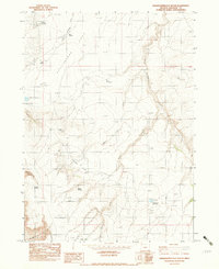
1982 Map of Grasshopper Flat South
USGS Topo · Published 1983About this map
Grasshopper Flat and Hansen Flat dominate this high-desert landscape in southeastern Oregon, as documented by the U.S. Geological Survey during a 1979 field check. This provisional edition reveals a terrain defined by water management and natural springs in an otherwise arid expanse. Small catchments like Echave Reservoir, Rosio Reservoir, and Trail Creek Reservoir are scattered across the flats, likely serving livestock or wild horse populations. Named features like Juana Forty Spring and Maiden Spring suggest a history of human activity and ranching heritage, while unique geological markers such as Hole-In-the-Ground and the steep incisions of Big Antelope Creek provide essential navigational landmarks. The map traces the intermittent flows of Tenmile Creek and Little Rattlesnake Creek, illustrating the complex drainage patterns that converge near Arcade Field.
Find a feature on this map
17 named features on this map. Tap any name to fly to it.
Don’t see what you’re looking for? This feature index may not catch every label — zoom into the map to look around manually.
Map Details
Editions of this 1982 Grasshopper Flat South Map
This is the sole edition of this map. No revisions or reprints were ever made.
Other maps of this area

1955 · Jordan Valley
USGS Topo · 1:250,000

1957 · Jordan Valley
USGS Topo · 1:250,000

1958 · Jordan Valley
USGS Topo · 1:250,000

1982 · Battle Mtn
USGS Topo · 1:24,000
1982 · Starvation Spring
USGS Topo · 1:24,000
1982 · Jackson Summit
USGS Topo · 1:24,000
1982 · Grasshopper Flat North
USGS Topo · 1:24,000
1982 · Tenmile Ranch
USGS Topo · 1:24,000
1982 · Chipmunk Basin
USGS Topo · 1:24,000
1982 · Hoppin Springs
USGS Topo · 1:24,000