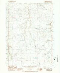
1982 Map of Chipmunk Basin
USGS Topo · Published 1983About this map
Chipmunk Basin defines this high-desert landscape in Malheur County, characterized by a complex network of seasonal water management features during the early 1980s. The map illustrates how ranching and land use relied on a system of isolated water sources, from the aptly named Disaster Spring and Exchange Spring to a series of catchment areas like Inspiration Reservoir and Horse Hill Reservoir. The presence of a long Buried Aqueduct winding through the southeastern terrain suggests a sophisticated infrastructure for transporting water across the arid stretches between Steer Canyon and Massey Canyon. Local industry is noted by scattered Gravel Pits, while landmarks like Horse Hill and the Bend-of-Pole Creek provide fixed points for navigating this intricate topography of draws and canyons.
Find a feature on this map
23 named features on this map. Tap any name to fly to it.
Don’t see what you’re looking for? This feature index may not catch every label — zoom into the map to look around manually.
Map Details
Editions of this 1982 Chipmunk Basin Map
This is the sole edition of this map. No revisions or reprints were ever made.
Other maps of this area

1955 · Jordan Valley
USGS Topo · 1:250,000

1957 · Jordan Valley
USGS Topo · 1:250,000

1958 · Jordan Valley
USGS Topo · 1:250,000
1982 · Starvation Spring
USGS Topo · 1:24,000

1982 · Guadalupe Meadows
USGS Topo · 1:24,000
1982 · Grasshopper Flat North
USGS Topo · 1:24,000
1982 · Rawhide Springs
USGS Topo · 1:24,000
1982 · Oregon Butte
USGS Topo · 1:24,000
1982 · Grasshopper Flat South
USGS Topo · 1:24,000
1982 · Hoppin Springs
USGS Topo · 1:24,000