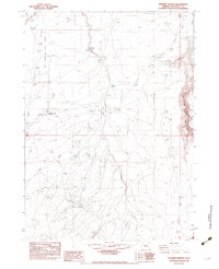
1982 Map of Rawhide Springs
USGS Topo · Published 1983About this map
Rawhide Springs and the surrounding desert rangelands of Malheur County define this landscape as it was surveyed in the late 1970s and early 1980s. The map illustrates a high-desert environment where water management and ranching infrastructure are the primary signs of human activity. Named ranching sites like Cathcart Place, Callahan Place, and Hill Place are scattered across the terrain, connected by primitive roads and a notable Drift Fence that suggests controlled livestock movement.
Find a feature on this map
18 named features on this map. Tap any name to fly to it.
Don’t see what you’re looking for? This feature index may not catch every label — zoom into the map to look around manually.
Map Details
Editions of this 1982 Rawhide Springs Map
This is the sole edition of this map. No revisions or reprints were ever made.
Other maps of this area

1955 · Jordan Valley
USGS Topo · 1:250,000

1957 · Jordan Valley
USGS Topo · 1:250,000

1958 · Jordan Valley
USGS Topo · 1:250,000
1982 · Rawhide Pocket
USGS Topo · 1:24,000
1982 · Starvation Spring
USGS Topo · 1:24,000
1982 · Peacock Lake
USGS Topo · 1:24,000

1982 · Guadalupe Meadows
USGS Topo · 1:24,000
1982 · Stoney Corral
USGS Topo · 1:24,000
1982 · No Crossing Crossing
USGS Topo · 1:24,000
1982 · Chipmunk Basin
USGS Topo · 1:24,000