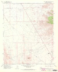
1967 Map of Grasshopper Junction
USGS Topo · Published 1968About this map
Grasshopper Junction sits at the southern edge of this Mohave County landscape, serving as a landmark in a territory defined by the broad Detrital Valley and the rising slopes of the Cerbat Mts. Surveyed in the late 1960s, the map reveals a rugged desert economy where water and minerals dictate the layout. Sparse infrastructure like Cottonwood Road and various Jeep Trails connect isolated corrals and water tanks, while signs of extraction are evident near Sugarloaf Mountain through marked Tailings and a Prospect. The complex drainage system is articulated by several seasonal flows, including Putman Wash, Detrital Wash, and Big Wash, which carve through the arid terrain. For researchers and genealogists, the placement of specific dry wells and springs like Quail Spring provides concrete evidence of the environmental challenges faced by those ranching and mining in this corner of Arizona.
Find a feature on this map
22 named features on this map. Tap any name to fly to it.
Don’t see what you’re looking for? This feature index may not catch every label — zoom into the map to look around manually.
Map Details
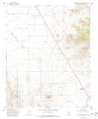
Editions of this 1967 Grasshopper Junction Map
2 editions found
Other maps of this area

1886 · Camp Mohave
USGS Topo · 1:250,000

1892 · Camp Mohave
USGS Topo · 1:250,000

1939 · Chloride
USGS Topo · 1:48,000

1942 · Camp Mohave
USGS Topo · 1:250,000

1944 · Chloride
USGS Topo · 1:62,500

1947 · Kingman
USGS Topo · 1:250,000

1948 · Kingman
USGS Topo · 1:250,000

1954 · Kingman
USGS Topo · 1:250,000

1955 · Kingman
USGS Topo · 1:250,000

1958 · Kingman
USGS Topo · 1:250,000