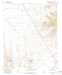
1967 Map of Grasshopper Junction
USGS Topo · Published 1985About this map
Grasshopper Junction sits at a critical desert crossroads in northwestern Arizona during the late 1960s, serving as a hub where the slopes of the Cerbat Mts meet the expansive Detrital Valley. The landscape is defined by its drainage patterns, with Putman Wash and Big Wash cutting through the arid terrain toward the south. Water management was clearly the priority for inhabitants of this era, evidenced by numerous Water Tanks and Corrals scattered across the range to support ranching operations. The eastern portion of the sheet rises sharply into the mountains, punctuated by Quail Spring and Sugarloaf Mountain. Signs of mineral exploration appear in the southwest, where a Prospect and area of Tailings suggest the persistent search for ore in the Mojave Desert. Transportation relies on the established Cottonwood Road and various unnamed tracks that navigate the valley floor.
Find a feature on this map
30 named features on this map. Tap any name to fly to it.
Don’t see what you’re looking for? This feature index may not catch every label — zoom into the map to look around manually.
Map Details
Editions of this 1967 Grasshopper Junction Map
2 editions found
Other maps of this area

1886 · Camp Mohave
USGS Topo · 1:250,000

1892 · Camp Mohave
USGS Topo · 1:250,000

1939 · Chloride
USGS Topo · 1:48,000

1942 · Camp Mohave
USGS Topo · 1:250,000

1944 · Chloride
USGS Topo · 1:62,500

1947 · Kingman
USGS Topo · 1:250,000

1948 · Kingman
USGS Topo · 1:250,000

1954 · Kingman
USGS Topo · 1:250,000

1955 · Kingman
USGS Topo · 1:250,000

1958 · Kingman
USGS Topo · 1:250,000