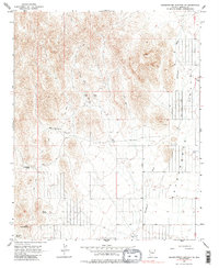
1967 Map of Grasshopper Junction SE
USGS Topo · Published 1985About this map
Sacramento Valley dominates the eastern half of this terrain, where the wide corridor of Sacramento Wash trends southward through a landscape defined by scarce water sources. The HJH Ranch is situated in the western foothills, serving as a primary human outpost in an area where life centered around reliable water points like Mud Spring and Cottonwood Spring. Multiple Water Tanks and wells are scattered across the valley floor to support livestock and transit.
Find a feature on this map
15 named features on this map. Tap any name to fly to it.
Don’t see what you’re looking for? This feature index may not catch every label — zoom into the map to look around manually.
Map Details
Editions of this 1967 Grasshopper Junction SE Map
Other maps of this area

1886 · Camp Mohave
USGS Topo · 1:250,000

1892 · Camp Mohave
USGS Topo · 1:250,000

1939 · Chloride
USGS Topo · 1:48,000

1942 · Camp Mohave
USGS Topo · 1:250,000

1944 · Chloride
USGS Topo · 1:62,500

1947 · Kingman
USGS Topo · 1:250,000

1948 · Kingman
USGS Topo · 1:250,000

1954 · Kingman
USGS Topo · 1:250,000

1955 · Kingman
USGS Topo · 1:250,000

1958 · Kingman
USGS Topo · 1:250,000