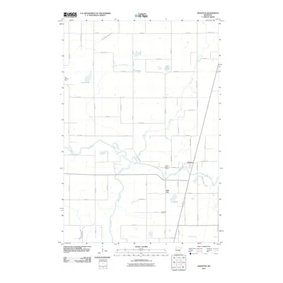
2010 Map of Grasston
USGS Topo · Published 2010About this map
The Snake River winds across this Kanabec County landscape, serving as the primary drainage for a region characterized by numerous small lakes and a systematic network of agricultural ditches. These drainage features, including County Ditch Number One and County Ditch Number Four, reflect the long-standing efforts to manage the water table in this low-lying area. The settlement of Grasston occupies the northern bank of the river, while the community of Grass Lake is situated further south near the water body of the same name. Local history and genealogy are anchored by the Grasston Union Cemetery and Grass Lake Cemetery, which provide permanent records of the early families who established these rural centers. Along the western edge of the map, the Gus Herwig Dam sits near Spence Lake, illustrating the small-scale water management infrastructure that has shaped the local hydrology and recreation for decades.
Find a feature on this map
51 named features on this map. Tap any name to fly to it.
Don’t see what you’re looking for? This feature index may not catch every label — zoom into the map to look around manually.
Map Details
Editions of this 2010 Grasston Map
This is the sole edition of this map. No revisions or reprints were ever made.
Other maps of this area

1953 · Stillwater
USGS Topo · 1:250,000

1955 · Stillwater
USGS Topo · 1:250,000

1958 · Stillwater
USGS Topo · 1:250,000

1961 · Cambridge
USGS Topo · 1:62,500

1961 · Brook Park
USGS Topo · 1:62,500

1961 · Springvale
USGS Topo · 1:24,000

1961 · Dalbo
USGS Topo · 1:62,500

1965 · Stillwater
USGS Topo · 1:250,000

1968 · Mora North
USGS Topo · 1:24,000
1968 · Mora South
USGS Topo · 1:24,000