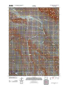
2011 Map of Grassy Ridge Well
USGS Topo · Published 2011About this map
Grassy Ridge Well marks a remote point of interest in this southeastern Oregon landscape, where water resources were vital for range management and settlement. The terrain is defined by the winding course of Wildcat Creek, which threads through the high desert draws of Malheur County. Overland travel is focused on the unimproved path of Wildcat Creek Rd, illustrating the sparse infrastructure common to this part of the state in the early 21st century. This survey documents the intersection of essential desert hydrology and the basic road networks required for livestock and ranching access in a region where named landmarks are rare.
Find a feature on this map
3 named features on this map. Tap any name to fly to it.
Don’t see what you’re looking for? This feature index may not catch every label — zoom into the map to look around manually.
Map Details
Editions of this 2011 Grassy Ridge Well Map
This is the sole edition of this map. No revisions or reprints were ever made.
Other maps of this area

1955 · Jordan Valley
USGS Topo · 1:250,000

1955 · Adel
USGS Topo · 1:250,000

1957 · Adel
USGS Topo · 1:250,000

1957 · Jordan Valley
USGS Topo · 1:250,000

1958 · Adel
USGS Topo · 1:250,000

1958 · Jordan Valley
USGS Topo · 1:250,000

1962 · Adel
USGS Topo · 1:250,000

1972 · Palomino Hills
USGS Topo · 1:24,000
1980 · Flat Top Mtn
USGS Topo · 1:24,000

1980 · Rome State Airport
USGS Topo · 1:24,000