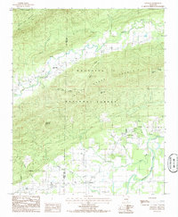
1985 Map of Gravelly
USGS Topo · Published 1986About this map
The Fourche La Fave River snakes through the valley of the Ouachita National Forest, defining the agricultural and social geography of this region in the mid-1980s. Small rural communities like Gravelly, Blue Ball, and Nola are connected by winding roads that navigate the complex terrain of the Ouachita Mountain range. The map reveals a landscape shaped by both natural watercourses and industrial activity, evidenced by an Oil Well tucked into a hollow south of the Dutch Creek valley.
Find a feature on this map
33 named features on this map. Tap any name to fly to it.
Don’t see what you’re looking for? This feature index may not catch every label — zoom into the map to look around manually.
Map Details
Editions of this 1985 Gravelly Map
This is the sole edition of this map. No revisions or reprints were ever made.
Other maps of this area

1879 · Mountain Home
USGS Topo · 1:62,500

1887 · Magazine Mountain #4
USGS Topo · 1:62,500

1887 · Mount Ida #2
USGS Topo · 1:62,500

1887 · Magazine Mountain #3
USGS Topo · 1:62,500

1887 · Magazine Mountain
USGS Topo · 1:62,500

1890 · Magazine Mountain
USGS Topo · 1:125,000

1890 · Mount Ida
USGS Topo · 1:125,000

1934 · Booneville
USGS Topo · 1:48,000

1939 · Booneville
USGS Topo · 1:62,500

1955 · Little Rock
USGS Topo · 1:250,000