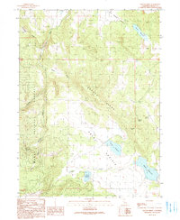
1990 Map of Graven Ridge
USGS Topo · Published 1990About this map
Graven Ridge dominates this northern California landscape, which is largely defined by the high-elevation terrain within the Modoc National Forest. This 1990 survey captures a region where water management is central to the land's utility, evidenced by a series of named reservoirs including Graves Reservoir, Grauen Reservoir, and Bayley Reservoir. These water bodies, along with numerous natural sources like Arnett Spring and Lunsford Spring, support the sparsely settled cattle and timber country typical of the Modoc Plateau.
Find a feature on this map
17 named features on this map. Tap any name to fly to it.
Don’t see what you’re looking for? This feature index may not catch every label — zoom into the map to look around manually.
Map Details
Editions of this 1990 Graven Ridge Map
This is the sole edition of this map. No revisions or reprints were ever made.
Other maps of this area

1886 · Alturas
USGS Topo · 1:250,000

1892 · Alturas
USGS Topo · 1:250,000

1954 · Alturas
USGS Topo · 1:250,000

1958 · Alturas
USGS Topo · 1:250,000

1961 · Canby
USGS Topo · 1:62,500

1961 · Alturas
USGS Topo · 1:62,500

1962 · Alturas
USGS Topo · 1:250,000
1962 · Adin
USGS Topo · 1:62,500

1962 · Likely
USGS Topo · 1:62,500

1965 · Alturas
USGS Topo · 1:250,000