
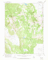
1962 Map of Likely
USGS Topo · Published 1964About this map
The Pit River and the Southern Pacific railroad corridor anchor the settlement of Likely in this northeastern California survey. This high-desert landscape is defined by the transition from the timbered heights of the Modoc National Forest and Warner Mountains down into the broad grazing lands of Ash Valley and the Madeline Plains. The map documents a working livestock landscape, marked by remote outposts like the Portuguese Sheep Camp and Fleming Sheep Camp, alongside essential water infrastructure such as the Nelson Reservoir and Spooner Reservoir. Significant local history is found in the siting of the Old Likely Mill and the South Fork Mountain Radio Facility, while numerous named springs like Yellowjacket Spring and Indian Springs highlight the critical role of water sources in this arid terrain. The boundary between Modoc and Lassen counties cuts through the southwestern corner, dividing the high ridges from the valley floors.
Find a feature on this map
55 named features on this map. Tap any name to fly to it.
Don’t see what you’re looking for? This feature index may not catch every label — zoom into the map to look around manually.
Map Details
Editions of this 1962 Likely Map
2 editions found
Other maps of this area

1886 · Alturas
USGS Topo · 1:250,000

1886 · Honey Lake
USGS Topo · 1:250,000

1891 · Honey Lake
USGS Topo · 1:250,000

1892 · Alturas
USGS Topo · 1:250,000

1893 · Honey Lake
USGS Topo · 1:250,000

1954 · Grasshopper Valley
USGS Topo · 1:62,500

1954 · Ravendale
USGS Topo · 1:62,500

1954 · Alturas
USGS Topo · 1:250,000

1955 · Westwood
USGS Topo · 1:250,000

1956 · Hayden Hill
USGS Topo · 1:62,500