
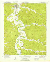
1936 Map of Graves Spring
USGS Topo · Published 1936About this map
Graves Spring and the surrounding hill country sit at the junction of Perry, Lewis, and Hickman Counties in the mid-1930s. This survey, compiled from aerial photographs for the Tennessee Valley Authority, reveals a landscape defined by an intricate network of narrow hollows such as Enoch Hollow and Mulberry Hollow. The settlement pattern follows the drainage of Coon Creek and Hurricane Creek, where small schools like Upper Brush Creek Sch and Upper Hurricane Creek Sch served the rural population.
Find a feature on this map
85 named features on this map. Tap any name to fly to it.
Don’t see what you’re looking for? This feature index may not catch every label — zoom into the map to look around manually.
Map Details
Editions of this 1936 Graves Spring Map
This is the sole edition of this map. No revisions or reprints were ever made.
Other maps of this area

1905 · Waynesboro
USGS Topo · 1:125,000

1936 · Riverside
USGS Topo · 1:24,000

1936 · Pleasantville
USGS Topo · 1:24,000

1936 · Beaverdam Springs
USGS Topo · 1:24,000

1936 · Linden
USGS Topo · 1:24,000

1936 · Leatherwood
USGS Topo · 1:24,000

1936 · Chestnut Grove
USGS Topo · 1:24,000

1936 · Kimmins
USGS Topo · 1:24,000

1936 · Topsy
USGS Topo · 1:24,000
1950 · Linden
USGS Topo · 1:24,000