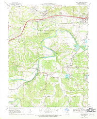
1969 Map of Gray Summit
USGS Topo · Published 1971About this map
The Meramec River winds through the central portion of this 1969 survey, defining a landscape of sharp river bends and heavy rail influence. The Missouri Botanical Garden Arboretum occupies a significant expanse within a large loop of the river, while the town of Pacific serves as a major node where the St Louis-San Francisco and Pacific railroads converge. These rail lines are central to the region's development, connecting settlements like Catawissa, Robertsville, and Gray Summit.
Find a feature on this map
51 named features on this map. Tap any name to fly to it.
Don’t see what you’re looking for? This feature index may not catch every label — zoom into the map to look around manually.
Map Details
Editions of this 1969 Gray Summit Map
This is the sole edition of this map. No revisions or reprints were ever made.
Other maps of this area

1901 · De Soto
USGS Topo · 1:125,000

1903 · O'Fallon
USGS Topo · 1:125,000

1937 · Pacific
USGS Topo · 1:24,000

1938 · Cedar Hill
USGS Topo · 1:24,000

1940 · Cedar Hill
USGS Topo · 1:24,000

1940 · Eureka
USGS Topo · 1:24,000

1944 · Eureka
USGS Topo · 1:24,000

1947 · St. Clair
USGS Topo · 1:62,500

1948 · Augusta
USGS Topo · 1:62,500

1949 · Saint Louis
USGS Topo · 1:250,000