
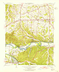
1940 Map of Eureka
USGS Topo · Published 1940About this map
Babler State Park dominates the northern bluffs of this Missouri landscape, where local life in the late 1930s centered around small schoolhouses and rural crossroads. The topography is defined by the steep drainage basins of Wildhorse Creek flowing toward the Missouri R in the northwest, and Carr Creek leading to the Meramec River in the southeast. Transportation corridors are clearly established by the Missouri Pacific and St Louis San Francisco railroads, which parallel Highway No 66 through the southern valley settlements of Allenton and Eureka.
Find a feature on this map
43 named features on this map. Tap any name to fly to it.
Don’t see what you’re looking for? This feature index may not catch every label — zoom into the map to look around manually.
Map Details
Editions of this 1940 Eureka Map
This is the sole edition of this map. No revisions or reprints were ever made.
Other maps of this area

1901 · De Soto
USGS Topo · 1:125,000

1903 · O'Fallon
USGS Topo · 1:125,000

1931 · Manchester SE
USGS Topo · 1:24,000

1931 · Pacific NE
USGS Topo · 1:24,000

1932 · Manchester NE
USGS Topo · 1:24,000

1937 · Pacific
USGS Topo · 1:24,000

1937 · Weldon Spring
USGS Topo · 1:24,000

1940 · Weldon Spring
USGS Topo · 1:24,000

1944 · Eureka
USGS Topo · 1:24,000
1945 · Manchester
USGS Topo · 1:24,000