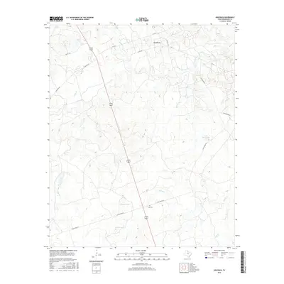
2016 Map of Grayback
USGS Topo · Published 2016About this map
The settlement of Grayback anchors the northern portion of this Wilbarger County landscape, situated at the junction of FM 1763 S and Alamosa Rd. The terrain is defined by an intricate network of drainage systems feeding into Beaver Cr, including Turkey Cr, Lillies Cr, and Hereford Br. This rural Texas expanse is dotted with numerous water management features such as Diving Board Tank, Stone Tank, and the twin N-Parker Tank and S-Parker Tank south of Coffee Creek Rd. A notable point of local history is found at Mack Cem, located just off Diving Board Rd, providing a genealogical focal point for the surrounding ranchlands. The map traces the path of a major transit corridor through the center of the quadrangle, where the shared route of US Highway 183 and 283 cuts a straight line through the rolling cattle country of the Rolling Plains.
Find a feature on this map
28 named features on this map. Tap any name to fly to it.
Don’t see what you’re looking for? This feature index may not catch every label — zoom into the map to look around manually.
Map Details
Editions of this 2016 Grayback Map
This is the sole edition of this map. No revisions or reprints were ever made.
Other maps of this area

1954 · Wichita Falls
USGS Topo · 1:250,000

1955 · Lawton
USGS Topo · 1:250,000

1958 · Wichita Falls
USGS Topo · 1:250,000

1958 · Davidson
USGS Topo · 1:62,500

1958 · Vernon
USGS Topo · 1:62,500

1966 · Franklin Bend
USGS Topo · 1:24,000

1966 · Santa Rosa Lake
USGS Topo · 1:24,000

1966 · Grayback
USGS Topo · 1:24,000
1966 · Lake Electra
USGS Topo · 1:24,000

1966 · Northeast Lake Kemp
USGS Topo · 1:24,000