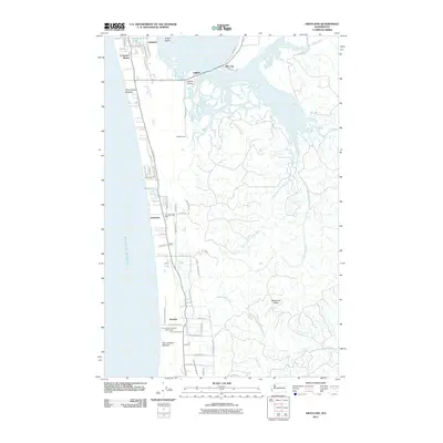
2011 Map of Grayland
USGS Topo · Published 2011About this map
Twin Harbors Beaches define this coastal landscape where the Pacific Ocean meets a series of inland lakes and cranberry bogs. This 2011 survey reveals a cluster of settlements including Grayland, Cohassett, and Bay City, situated along a low-lying strip of land separated from the mainland by the Elk River and Mallard Slough. The infrastructure reflects a blend of residential pockets and recreation, with sites like the Grayland Post Office and Kenanna Recreational Vehicle Park positioned among a grid of local roads such as Cranberry Rd and Marine Dr.
Find a feature on this map
61 named features on this map. Tap any name to fly to it.
Don’t see what you’re looking for? This feature index may not catch every label — zoom into the map to look around manually.
Map Details
Editions of this 2011 Grayland Map
This is the sole edition of this map. No revisions or reprints were ever made.
Other maps of this area

1938 · Cape Shoalwater
USGS Topo · 1:62,500

1938 · South Bend
USGS Topo · 1:62,500

1940 · South Bend
USGS Topo · 1:62,500

1941 · Grayland
USGS Topo · 1:62,500

1943 · Copalis Beach
USGS Topo · 1:250,000

1951 · Copalis Beach
USGS Topo · 1:250,000

1953 · Hoquiam
USGS Topo · 1:250,000

1955 · Point Brown
USGS Topo · 1:24,000
1956 · North Cove
USGS Topo · 1:24,000
1956 · Westport
USGS Topo · 1:24,000