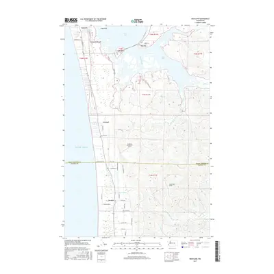
2017 Map of Grayland
USGS Topo · Published 2017About this map
Grayland and the surrounding coastal corridor of Southwest Washington are defined by a landscape of narrow lakes and tidewaters tucked behind the dunes of the Pacific Ocean. This survey captures the transition from the beachside communities of Cohassett and Heather to the salt marshes of South Bay and Sopun Inlet. A unique local landmark, the Grayland Intergalactic Airport, sits central to the quadrangle, illustrating the eccentricities of this remote coastal stretch. The drainage patterns of the Elk River and Andrews Creek carve through the inland rising ground toward Seastrand Ridge, while the road network, including Cranberry Rd and Sea Hurst Rd, connects the low-lying settlements. The presence of numerous named water bodies like Long Lake and Horseshoe Lake underscores the high water table and marshy character of this cranberrry-growing region.
Find a feature on this map
52 named features on this map. Tap any name to fly to it.
Don’t see what you’re looking for? This feature index may not catch every label — zoom into the map to look around manually.
Map Details
Editions of this 2017 Grayland Map
This is the sole edition of this map. No revisions or reprints were ever made.
Other maps of this area

1938 · Cape Shoalwater
USGS Topo · 1:62,500

1938 · South Bend
USGS Topo · 1:62,500

1940 · South Bend
USGS Topo · 1:62,500

1941 · Grayland
USGS Topo · 1:62,500

1943 · Copalis Beach
USGS Topo · 1:250,000

1951 · Copalis Beach
USGS Topo · 1:250,000

1953 · Hoquiam
USGS Topo · 1:250,000

1955 · Point Brown
USGS Topo · 1:24,000
1956 · North Cove
USGS Topo · 1:24,000
1956 · Westport
USGS Topo · 1:24,000