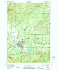
1950 Map of Grayling
USGS Topo · Published 1989About this map
Grayling stands as a central hub in Crawford County, defined by the convergence of the Au Sable River and the New York Central railroad lines. The landscape reflects a transition from civic development to managed wilderness and military utility during the mid-century. To the north, the Hartwick Pines State Park preserves the region’s lumbering heritage at the Lumbermens Museum and Major Hartwick Museum, while the Camp Grayling Military Reservation occupies a massive footprint across the central plains.
Find a feature on this map
32 named features on this map. Tap any name to fly to it.
Don’t see what you’re looking for? This feature index may not catch every label — zoom into the map to look around manually.
Map Details
Editions of this 1950 Grayling Map
2 editions found
Other maps of this area

1949 · Otsego Lake
USGS Topo · 1:62,500

1949 · Fletcher
USGS Topo · 1:62,500

1949 · Grayling
USGS Topo · 1:62,500

1950 · Cote Dame Marie
USGS Topo · 1:24,000

1950 · Lake Margrethe
USGS Topo · 1:24,000

1950 · Grayling
USGS Topo · 1:24,000

1950 · Roscommon North
USGS Topo · 1:24,000

1951 · K P Lake
USGS Topo · 1:24,000

1951 · Big Bradford Lake
USGS Topo · 1:24,000

1951 · Wakeley Lake
USGS Topo · 1:24,000
Featured Places
- Grayling, MI
- Frederic Township, MI
- Grayling Charter Township, MI
- Louis Cabin Landing, MI
- Crawford County, MI