
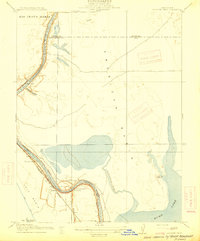
1916 Map of Grays Bend
USGS Topo · Published 1916About this map
Rio Jesus Maria land grant territory dominates this 1916 survey, capturing a landscape of complex water management and early Central Valley agriculture. The meandering Sacramento River forms the eastern boundary, marked by the engineering of the Elkhorn Weir and the adjacent Tule Canal, which together illustrate the era's sophisticated flood control efforts. The central portion of the sheet is defined by the Sacramento and Woodland railroad, which served as a vital transit artery connecting the small station stops of Hebron and Elkhorn. To the north, Cache Creek flows into the expansive Cache Creek Sink, while the southern reaches are drained by the winding Willow Slough. Family-named settlements like Langenour and Curtis reflect the localized nature of early twentieth-century rural life in Yolo County before later regional consolidation.
Find a feature on this map
14 named features on this map. Tap any name to fly to it.
Don’t see what you’re looking for? This feature index may not catch every label — zoom into the map to look around manually.
Map Details
Editions of this 1916 Grays Bend Map
This is the sole edition of this map. No revisions or reprints were ever made.
Other maps of this area

1907 · Dunnigan
USGS Topo · 1:62,500

1907 · Woodland
USGS Topo · 1:62,500

1907 · Davisville
USGS Topo · 1:62,500

1910 · Knights Landing
USGS Topo · 1:31,680

1910 · Vernon
USGS Topo · 1:31,680

1915 · Yolo
USGS Topo · 1:31,680

1915 · Swingle
USGS Topo · 1:31,680

1915 · Ronda
USGS Topo · 1:31,680
1915 · Elkhorn Weir
USGS Topo · 1:31,680

1915 · Merritt
USGS Topo · 1:31,680