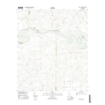
2017 Map of Grays Landing
USGS Topo · Published 2017About this map
The Altamaha River carves a complex course through this landscape, marking the convergence of Montgomery, Toombs, Jeff Davis, and Appling counties. The river's influence is evident in the dense network of wetlands and secondary waterways like Bullards Creek and Little Alligator Creek that dominate the lowlands. At Grays Landing, the terrain transitions from the river bottom to higher ground marked by a series of family-named cemeteries and rural roads. Genealogists and local historians can find many legacy sites, including Moseley Cem, Old Smyrna Cem, and Partin Cem. The presence of McNatt Falls and Grays Landing Lake highlights the unique hydrography of the region, where the slow-moving river system creates numerous oxbows and swampy inlets essential to the local environment and history.
Find a feature on this map
78 named features on this map. Tap any name to fly to it.
Don’t see what you’re looking for? This feature index may not catch every label — zoom into the map to look around manually.
Map Details
Editions of this 2017 Grays Landing Map
This is the sole edition of this map. No revisions or reprints were ever made.
Other maps of this area

1953 · Waycross
USGS Topo · 1:250,000

1957 · Macon
USGS Topo · 1:250,000

1958 · Macon
USGS Topo · 1:250,000

1958 · Waycross
USGS Topo · 1:250,000

1964 · Macon
USGS Topo · 1:250,000

1970 · Johnson Corner
USGS Topo · 1:24,000

1970 · Alston
USGS Topo · 1:24,000

1970 · Uvalda
USGS Topo · 1:24,000

1970 · Baxley NE
USGS Topo · 1:24,000

1970 · Pine Grove
USGS Topo · 1:24,000