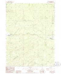
1985 Map of Grays Peak
USGS Topo · Published 1985About this map
Lassen National Forest terrain dominates this 1980s landscape, characterized by complex drainage patterns and high ridges along the border of Shasta and Tehama counties. Significant elevations include Grays Peak and the prominent Blue Ridge, which overlooks a series of deep ravines like Snoqualmie Gulch and Blue Gulch. Small-scale human activity is represented by Groves and the seasonal Camp Forward, which sit near the upper reaches of South Fork Digger Creek.
Find a feature on this map
29 named features on this map. Tap any name to fly to it.
Don’t see what you’re looking for? This feature index may not catch every label — zoom into the map to look around manually.
Map Details
Editions of this 1985 Grays Peak Map
This is the sole edition of this map. No revisions or reprints were ever made.
Other maps of this area

1886 · Lassen Peak
USGS Topo · 1:250,000

1892 · Lassen Peak
USGS Topo · 1:250,000

1894 · Lassen Peak
USGS Topo · 1:250,000

1935 · Burney
USGS Topo · 1:96,000

1935 · Paynes Creek
USGS Topo · 1:96,000

1939 · Burney
USGS Topo · 1:125,000

1941 · Mineral
USGS Topo · 1:125,000

1955 · Westwood
USGS Topo · 1:250,000

1956 · Lassen Peak
USGS Topo · 1:62,500

1956 · Manton
USGS Topo · 1:62,500