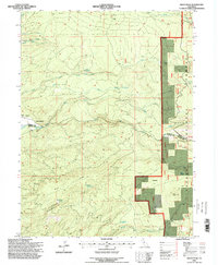
1995 Map of Grays Peak
USGS Topo · Published 1998About this map
The timbered elevations of the Lassen National Forest dominate this mid-1990s survey, illustrating a landscape defined by forest management and local industry at the Shasta and Tehama county line. Industrial and recreational markers such as the Forward Mill, Camp Forward, and a nearby Landing Field sit west of the steep drainages. The topography is deeply incised by the South Fork Digger Creek and Onion Creek, while the eastern portion of the map centers on the namesake Grays Peak. Cultural sites like the Rockland School and the settlement at Graves point to the area's rural history. Traces of historical land use are also evident in named clearings and flats, including Sugarpine Flat and Hazen Flat, while natural springs like Rattlesnake Spring and Blue Ridge Spring mark the high ridges.
Find a feature on this map
29 named features on this map. Tap any name to fly to it.
Don’t see what you’re looking for? This feature index may not catch every label — zoom into the map to look around manually.
Map Details
Editions of this 1995 Grays Peak Map
This is the sole edition of this map. No revisions or reprints were ever made.
Other maps of this area

1886 · Lassen Peak
USGS Topo · 1:250,000

1892 · Lassen Peak
USGS Topo · 1:250,000

1894 · Lassen Peak
USGS Topo · 1:250,000

1935 · Burney
USGS Topo · 1:96,000

1935 · Paynes Creek
USGS Topo · 1:96,000

1939 · Burney
USGS Topo · 1:125,000

1941 · Mineral
USGS Topo · 1:125,000

1955 · Westwood
USGS Topo · 1:250,000

1956 · Lassen Peak
USGS Topo · 1:62,500

1956 · Manton
USGS Topo · 1:62,500