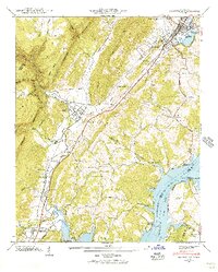
1942 Map of Graysville
USGS Topo · Published 1956About this map
The Cumberland Escarpment dominates the western landscape of this 1942 survey, where the steep terrain drops into the fertile Cranmore Cove and the widening valley of Sale Creek. This era captures the region shortly after the creation of Chickamauga Lake, showing the submerged riverbed and the remaining Blythe Ferry crossing near the junction with the Hiwassee River.
Find a feature on this map
70 named features on this map. Tap any name to fly to it.
Don’t see what you’re looking for? This feature index may not catch every label — zoom into the map to look around manually.
Map Details
Editions of this 1942 Graysville Map
2 editions found
Other maps of this area

1886 · Cleveland
USGS Topo · 1:125,000

1887 · Kingston
USGS Topo · 1:125,000

1888 · Chattanooga
USGS Topo · 1:125,000

1891 · Kingston
USGS Topo · 1:125,000

1892 · Pikeville
USGS Topo · 1:125,000

1892 · Cleveland
USGS Topo · 1:125,000

1893 · Chattanooga
USGS Topo · 1:125,000

1893 · Kingston
USGS Topo · 1:125,000

1895 · Cleveland
USGS Topo · 1:125,000

1895 · Pikeville
USGS Topo · 1:125,000