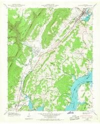
1942 Map of Graysville
USGS Topo · Published 1968About this map
Dayton and the surrounding river bottoms of the Hiwassee River are depicted here just as the landscape was transforming under the influence of the Tennessee Valley Authority. This 1942 field examination shows the early years of Chickamauga Lake as it filled the valley, bordering the Chickamauga Reservation. The area's settlement pattern is defined by the sharp rise of the Cumberland Escarpment to the west, which forces development into the narrow corridor of Cranmore Cove and along the Southern RR. Local genealogy is well-represented through numerous family and community burial grounds, including the Old Browder Cem and Mc Donald Cem. The map provides a look at rural social infrastructure through landmarks like the New Providence Sch and Mountain View Ch, while the industrial and transport hub of Graysville sits at the junction of Sale Creek and the rail line.
Find a feature on this map
63 named features on this map. Tap any name to fly to it.
Don’t see what you’re looking for? This feature index may not catch every label — zoom into the map to look around manually.
Map Details
Editions of this 1942 Graysville Map
2 editions found
Other maps of this area

1886 · Cleveland
USGS Topo · 1:125,000

1887 · Kingston
USGS Topo · 1:125,000

1888 · Chattanooga
USGS Topo · 1:125,000

1891 · Kingston
USGS Topo · 1:125,000

1892 · Pikeville
USGS Topo · 1:125,000

1892 · Cleveland
USGS Topo · 1:125,000

1893 · Chattanooga
USGS Topo · 1:125,000

1893 · Kingston
USGS Topo · 1:125,000

1895 · Cleveland
USGS Topo · 1:125,000

1895 · Pikeville
USGS Topo · 1:125,000